Empire Outlets
Built atop sections of the existing Empire Outlets complex (EAS p. 11c).
1,200 residential units / 240 to 360 MIH units
 3Dstaten.nycStaten Island in three dimensions.
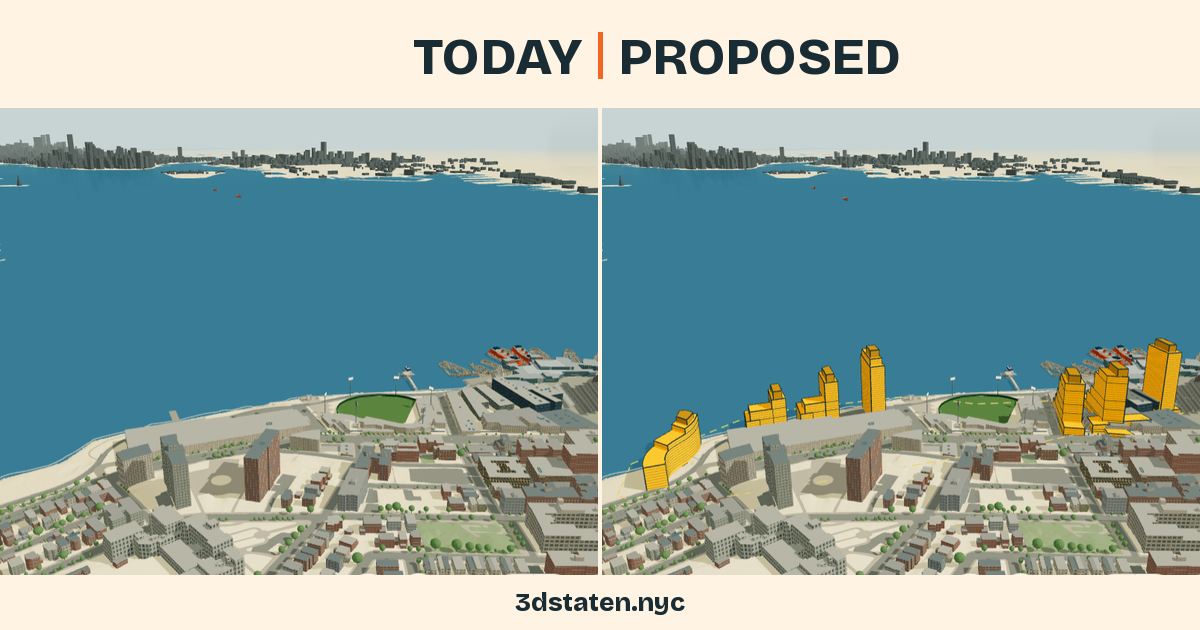
Seven proposed buildings. Three sites. See the plan beside what’s here today.
Loading review status…
Built atop sections of the existing Empire Outlets complex (EAS p. 11c).
1,200 residential units / 240 to 360 MIH units
Between the terminal building, the garage and the waterfront (EAS p. 11c).
1,000 residential units / 200 to 300 MIH units
Vacant parcel west of the garage, includes part of Bank Street (EAS p. 11a).
300 residential units / 60 to 90 MIH units
MIH means Mandatory Inclusionary Housing. Unit figures are from the supplied assessment dataset.
Illustrative massingSeven reconstructed building forms follow the supplied September 2026 public presentation, with heights and quantities retained from the North Shore Waterfront Plan assessment. Placement and intermediate dimensions remain approximate; the slides label these designs illustrative.
Scroll sideways for bulkhead heights and gross floor area.
| Building | Stories | Roof | Bulkhead | Gross sq ft |
|---|---|---|---|---|
| Site 1 Building 1 | 22 | 242 ft | +35 ft | 338,350 |
| Site 1 Building 2 | 25 | 266 ft | +35 ft | 398,450 |
| Site 1 Building 3 | 30 | 319 ft | +35 ft | 348,850 |
| Site 2 Building 1 | 30 | 319 ft | +35 ft | 326,800 |
| Site 2 Building 2 | 22 | 232 ft | +35 ft | 323,600 |
| Site 2 Building 3 | 17 | 182 ft | +35 ft | 249,550 |
| Site 3 Building 1 | 13 | 147 ft | +25 ft | 259,400 |
Roof height is above local ground; the bulkhead is additional height. Gross floor area describes each supplied envelope, not the total project’s existing and proposed floor area.
The shape reference is the supplied September 2026 Staten Island St George Housing Plan presentation: slides 30–33 and 35, attributed to NYCEDC, the Mayor’s Office and FXCollaborative. The screenshots were supplied from the September 29 meeting.
Site 1 uses the shown stepped profiles, cross wings and separate tower. Site 2 preserves the tower-and-wing forms and their 30, 22 and 17-story sequence. Site 3 follows the curved waterfront profile and a 13-story maximum.
Open any image to inspect the original slide.
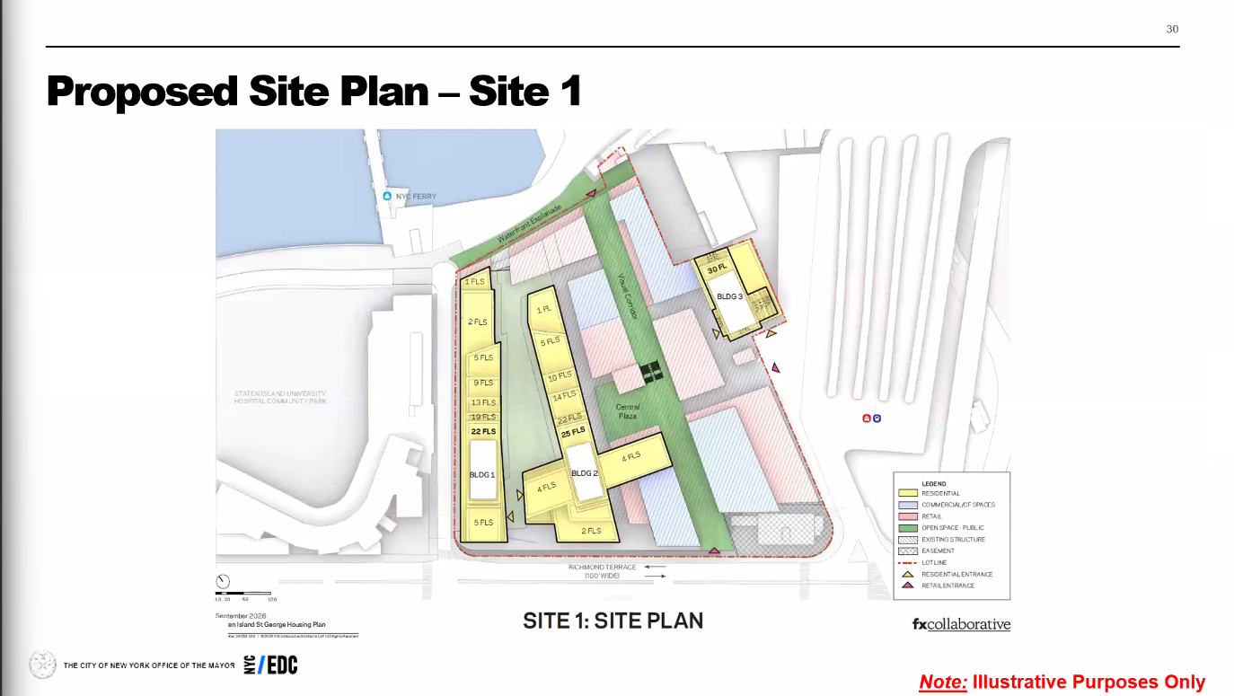
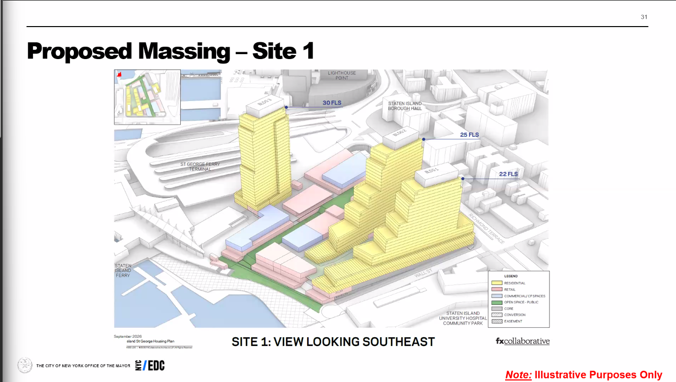
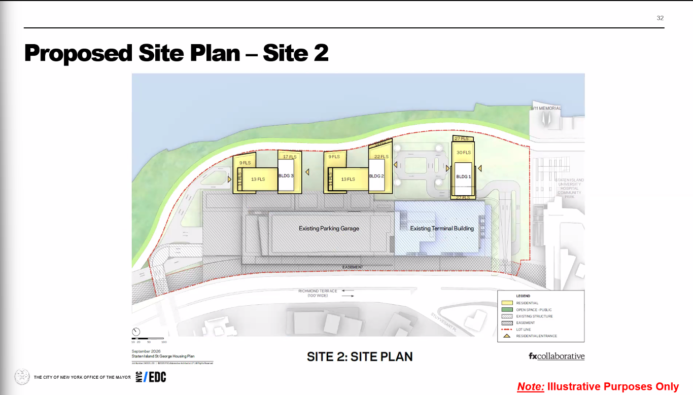
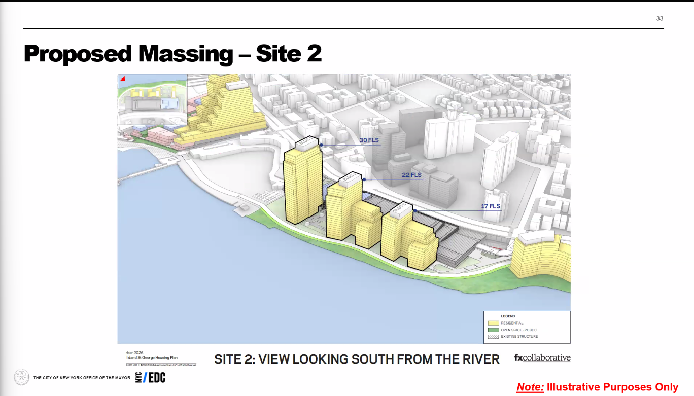
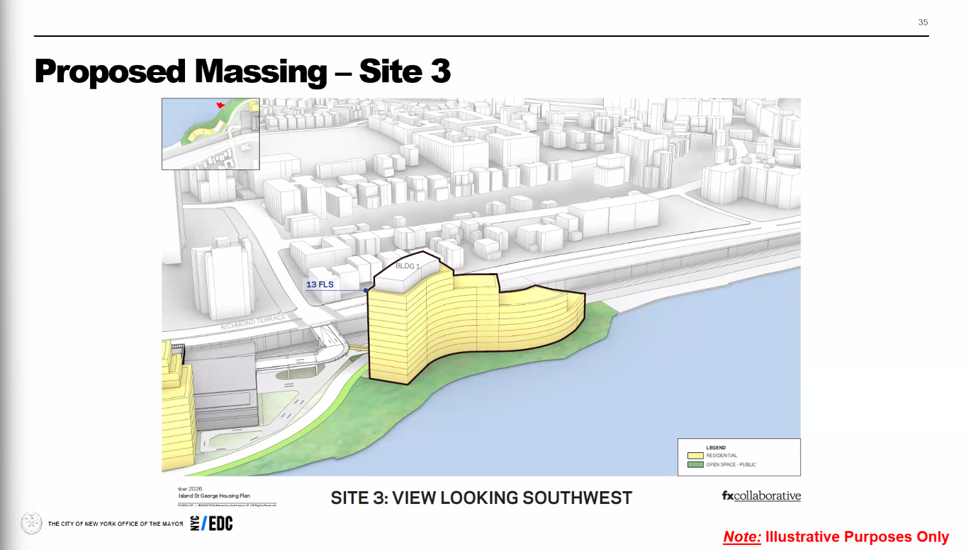
Sites 1 and 2 use traces of the supplied site plans, aligned approximately to recognizable existing structures. Site 3 is interpreted from its perspective illustration because a full plan was not supplied. Floor lines show the story counts; the EAS roof and bulkhead figures set maximum elevations.
These reconstructions communicate the presented forms. Footprints, setbacks, intermediate heights and placement are approximate. Gross floor-area values remain the source assessment figures and are not recalculated from this illustrative geometry. The dashed amendment outline is also approximate.
Existing buildings stay visible for context. Use the Proposal and site switches to compare all three sites, or select a proposed building to open its matching presentation slide.
Source: NYCEDC, North Shore Waterfront Plan Environmental Assessment Statement, CEQR 26DME018R, August 26, 2026, Additional Information pages 11c–11d and Table 1.
NYCEDC publishes the assessment, draft scope and scoping materials on its environmental review page. Consult that page for the current review status and participation details.
Read the official participation instructions. Verified deadline and recipient details load below.
Official participation instructions
Reference CEQR 26DME018R. Source: CEQR 26DME018R Draft Scope notice, checked Oct 2 2026 by owner. This independent model does not submit formal comments.